
| Home | Contact Infomation | Statistics Explained | Map Information | Scope | Current Conditions |
|---|
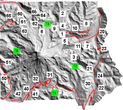 The purpose of this web site is to provide quick access to trail
information for the serous hiker on Mt. Rainier trails. This information can be accessed in
two ways. The first way is designed to allow you to access the trail
descriptions by geographic location by just mouse clicking over the
appropriate square in the map. Alternatively you can click on the
corresponding row (i.e. trail names for each map id are found in the table)
in the associated table. This table is designed to provide a physical
context for each trial by giving a short summary of trail statistics.
The purpose of this web site is to provide quick access to trail
information for the serous hiker on Mt. Rainier trails. This information can be accessed in
two ways. The first way is designed to allow you to access the trail
descriptions by geographic location by just mouse clicking over the
appropriate square in the map. Alternatively you can click on the
corresponding row (i.e. trail names for each map id are found in the table)
in the associated table. This table is designed to provide a physical
context for each trial by giving a short summary of trail statistics.
| ID | Name | Trail Length(Miles) |
Effective Distance |
High point | Low Point | Hiking Time | Hiking Season | Status |
|---|---|---|---|---|---|---|---|---|
| 1 | Burroughs Mt. Loop |
5.4 | 7.7 | 7180 | 6190 | 3 hr | Late July-Sep | Annotated |
| 2 | Grand Park | 10.0 | 12.7 | 6800 | 4874 | 1-2 day | Mid July-Sep | Annotated |
| 3 | Indian Bar | 16.5 | 25.3 | 6760 | 3000 | 2 days | Late-July-Sep | Annotated |
| 4 | Mt. Fremont Lookout | 3 | 4.4 | 7170 | 6400 | 4.4 hr | Mid July-Sep | Annotated |
| 5 | Glacier Basin | 3.6 | 5.6 | 6200 | 4300 | 4 hr | July-Sep | Summarized |
| 6 | Sunrise-Carbon River | 16.6 | 23.2 | 6800 | 2340 | 2 days | Mid July-Sep | Planned |
| 7 | Owyhigh | 8.6 | 12.8 | 5400 | 2900 | 5 hrs | Mid July-Sep | Annotated |
| 8 | Palisades | 3.7 | 5.8 | 6140 | 5504 | 5 hr. | Mid July-Sept | Annotated |
| 9 | Skyscraper | 3.8 | 5.2 | 6800 | 6320 | 4 hr | Mid July-Sept | Annotated |
| 10 | Sourdough | 2.9 | 3.9 | 6810 | 6126 | 2 hrs | Mid July-Sept | Annotated |
| 11 | Summerland | 4.4 | 7.1 | 5940 | 3810 | 4 hr | July-Sept | Annotated |
| 20 | Crystal Lakes | 3.4 | 6.1 | 5830 | 3530 | 3 hr | Mid July to Sept | >Annotated |
| 21 | East Side | 12.25 | 16.5 | 5345 | 1854 | 6 hr. | July-Mid Nov. | Planned |
| 22 | Laughingwater Creek | 5.6 | 9. | 4840 | 2170 | 6 hr | July-Sept | Planned |
| 23 | Naches | 3.4 | 4.5 | 5890 | 5340 | 3 hr | Mid July-Oct | Annotated |
| 24 | Shriner Peak | 4.1 | 8.2 | 5820 | 2420 | 5 hr | July-Oct | Planned |
| 30 | Cowlitz Divde | 4.1 | 6.8 | 4760 | 2320 | 8 hr. | July-Sept | Summarized |
| 31 | Skyline | 5.1 | 8.8 | 6780 | 5430 | 4 hr | Late July- Mid Sept | Planned |
| 32 | Van Trump Loop |
6.9 | 11.0 | 5530 | 2800 | 6 hr. | Mid July- Mid Oct | Annotated |
| 40 | Rampart Ridge | 4.9 | 7.5 | 4060 | 2700 | 3 hr. | Mid June - Oct | Planned |
| 41 | Eagle Peak | 3.5 | 6.8 | 5735 | 2807 | 5 hr. | July-Oct. | Annotated |
| 42 | Kautz Creek | 12.6 | 19.2 | 5650 | 2400 | 1 day | Mid July- Mid Oct. | Planned |
| 50 | Gobblers Knob | 2.0 (+8 road) |
4.0 | 5480 | 3890 | 2 hr(if road open) |
Late July-Sept | Annotated |
| 51 | Klapatche Park | 7.5 (+16 road) |
13 | 5550 | 3550 | 2 days(if road closed) |
Mid July-Mid Oct. | Summerized |
| 60 | Ipsut Pass | 3.8 | 7.5 | 5240 | 2340 | 3 hr | July-Oct | Annotated |
| 61 | Mowich Loop | 16.4 | 26.3 | 6380 | 2330 | 2 days | Mid July-Oct | Annotated |
| 62 | Mystic Lake | 7.6 | 12.5 | 6080 | 2340 | 8 hr | Mid July- Oct | Planned |
| 63 | Spray Park | 3.6 | 6.2 | 6030 | 4557 | 3 hr. | late July-Oct | Annotated |
| 64 | Windy Gap | 8.2 | 13.1 | 5830 | 2340 | 9 hr | Mid July-Mid Oct | Planned |
| 65 | Tolmie Peak | 2.9 | 4.4 | 5900 | 4900 | 3 hr. | Mid July-Sept | Annotated |
| 66 | North Loop | 35 | 53 | 6730 | 2340 | 4 days | Mid July-Sept | Planned |
| 70 | Wonderland West | 33.7 | 55.1 | 6020 | 2620 | 4-7 Days | Mid July-Sept | Planned |
| 71 | Wonderland North | 21.3 | 32.2 | 6780 | 2340 | 2-4 days | Mid July-Sept | Annotated |
| 72 | Wonderland East | 21.7 | 32.1 | 6760 | 2300 | 2 days | Late July-Sept | Annotated |
| 73 | Wonderland South | 12.5 | 17.5 | 4880 | 2590 | 1-2 days | July-Sept. | Annotated |